How the Big Sur Highway Was Built: The Remarkable History of California's Highway 1
From a shipwreck in 1894 to prison labor camps, massive dynamite blasts, and the engineering achievement of Bixby Creek Bridge, this is the story of the road that opened California's most spectacular coastline.
Today, driving Highway 1 through Big Sur feels almost inevitable. The road curves around towering cliffs, crosses deep canyons, and reveals some of the most beautiful views along the California coast. At Bixby Creek Bridge, the highway seems to float between the Santa Lucia Mountains and the Pacific Ocean, fitting so naturally into the landscape that it is easy to forget that little more than a century ago, much of this road did not exist.
Building Highway 1 through Big Sur was an extraordinary engineering achievement that required decades of political determination, massive rock excavation, powerful dynamite blasts, prison labor camps, and millions of dollars. Engineers and construction crews faced the daunting task of carving a modern highway into one of California's most rugged and unstable coastlines, a challenge that would take nearly two decades to complete.
I have driven this coast more times than I can count, often with a paint box in the back of my car and an eye on the changing light. Over the years, I have stood beside the highway painting the ocean, camped above its cliffs, and explored its beaches with my family. Yet the more time I spend in Big Sur, the more I appreciate the road itself. Every turnout where I set up an easel, every canyon crossing, and every stretch of highway cut into the mountainside exists because people undertook an almost unimaginable construction project.
Understanding how the Big Sur highway was built reveals a remarkable chapter of California history and makes the drive itself even more extraordinary.
Planning a visit? My Big Sur Road Trip Itinerary & Travel Guide covers 24 scenic stops, beaches, campgrounds, photography locations, and one-, two-, and three-day itineraries.
Before Highway 1: A Coast Almost Cut Off From the World
Long before Europeans arrived, Indigenous communities, including the Esselen and neighboring peoples, knew and traveled this coastline. By the nineteenth century, settlers had established ranches and homesteads throughout Big Sur, but transportation between communities remained difficult, particularly during the winter months when heavy rains could make the few existing trails nearly impassable.
A rough wagon road extended south from Carmel toward the Big Sur River, but beyond that point, much of the coastline could be reached only by horseback, on foot, or by sea. The Santa Lucia Mountains rise abruptly from the Pacific, leaving little level ground between steep mountain slopes and the ocean. Deep canyons divide the landscape, while frequent landslides and unstable rock formations made the construction of dependable roads extraordinarily difficult.
Before the modern highway, residents relied partly on ships to deliver supplies to small coastal landings. These primitive ports, sometimes called dog-hole ports, allowed vessels to load and unload lumber, agricultural products, and essential goods along an otherwise inaccessible coastline. Transporting heavy equipment or construction materials inland from these landings was often an enormous undertaking.
At Bixby Creek, the old coastal route could not cross the deep canyon directly and instead turned inland through the mountains. Portions of that historic route survive today as Old Coast Road, offering a glimpse of how difficult travel through the region once was.
The isolation that makes Big Sur feel so special to visitors today was once a serious obstacle for the people who lived there. Reaching a neighboring community could require hours of difficult travel, while obtaining medical assistance or transporting goods presented challenges that are difficult to imagine from the comfort of a modern automobile.
The Shipwreck That Helped Inspire Highway 1
The story of the modern Big Sur highway is closely connected to a shipwreck that occurred near Point Sur on April 21, 1894, when the steamship Los Angeles ran aground along the rocky coastline.
Dr. John L. D. Roberts, a physician from the Monterey Peninsula and founder of Seaside, traveled south in a horse-drawn wagon to assist those involved in the disaster. The difficult journey took approximately three and a half hours, reinforcing his belief that the isolated communities along this coastline desperately needed a reliable road.
In 1897, Roberts traveled between Monterey and San Simeon, studying the terrain and considering where a highway might be constructed. At the time, he estimated that such a road could be completed for approximately $50,000, a figure that would eventually prove spectacularly optimistic.
Roberts recognized that a highway would provide more than transportation for local residents. He also understood the extraordinary appeal of the Big Sur landscape and believed that visitors would travel great distances simply to experience its dramatic scenery. He spent years advocating for the project, promoting it as both a practical improvement for coastal communities and an opportunity to open one of California's most remarkable regions to the public.
Eventually, his persistence attracted the attention of a powerful political ally who would help transform the idea into a state-supported highway project.
How Highway 1 Was Approved: The Military Highway Argument
California State Senator Elmer S. Rigdon of Cambria became one of the most important supporters of the proposed Carmel–San Simeon Highway. Rigdon understood that obtaining public funding for a road through sparsely populated mountains would be politically difficult, particularly when other parts of California were requesting highways to connect growing cities, farming regions, and commercial centers.
The proposed Big Sur route offered few immediate commercial benefits, but the political climate surrounding World War I presented supporters with another argument. A continuous highway along the California coast could provide a transportation corridor with potential military and national-defense value, allowing troops and equipment to move through an otherwise inaccessible section of the state's western coastline.
This defense argument helped give the proposal importance beyond tourism and local transportation. Following years of lobbying, surveys, and political debate, California voters approved the Third State Highway Bond Issue on July 1, 1919. The statewide program authorized $40 million in highway bonds, with approximately $1.5 million allocated for the Carmel–San Simeon route.
After decades of advocacy, the project finally had official approval and a source of public funding. What remained was the considerably more difficult task of determining how to construct a modern automobile highway through miles of unstable coastal mountains.
Senator Rigdon died in 1922, long before the project was completed, but his political efforts helped make the highway possible.
Construction Begins: Carving a Highway Into the Mountains
Construction began in the early 1920s, with crews working from different sections of the proposed route. Unlike highways built across valleys or relatively level terrain, much of the Big Sur road had to be excavated directly into steep mountainsides, frequently hundreds of feet above the Pacific Ocean.
The engineering challenges were extraordinary for the period. Construction crews relied on steam shovels, air compressors, rock drills, explosives, and temporary access tracks to remove material from the cliffs. Heavy machinery sometimes operated on narrow shelves where a landslide or mechanical failure could send equipment tumbling toward the ocean far below.
At particularly remote construction sites, equipment and supplies had to be transported by boat to small coastal landings, then hauled up the cliffs using steam-powered winches known as donkey engines. Even getting machinery into position could require substantial engineering work before excavation of the actual highway could begin.
Landslides constantly disrupted progress as newly exposed slopes gave way under the weight of machinery or after heavy rainfall. Equipment was buried, damaged, or stranded, and workers sometimes had to clear enormous quantities of fallen rock before they could resume construction. Contemporary highway reports described the exceptional difficulties faced by steam-shovel operators working along the unstable coastline.
The graceful curves that travelers enjoy today were created through an exhausting process of drilling, blasting, excavating, moving rock, and repairing slopes. Progress was slow, expensive, and frequently interrupted by conditions that engineers had underestimated.
By 1924, much of the original funding had been exhausted, and construction slowed dramatically. Despite several years of effort, substantial sections of the proposed highway remained unfinished, including some of the most difficult terrain along the coast.
Prison Labor Camps Helped Complete Highway 1
Construction resumed in 1928 with an additional source of labor that became an important and controversial part of the highway's history. California established temporary prison camps along the Big Sur coast, bringing incarcerated men from the state prison system to work on the unfinished road.
The camps operated at several locations, including areas near the Little Sur River, Kirk Creek, and Anderson Canyon. As work progressed, camps and crews moved to different sections of the highway, allowing construction to continue through remote areas where housing and supplying a large civilian workforce would have been particularly difficult.
Prisoners performed much of the physically demanding manual labor, while skilled civilian workers generally operated heavy equipment, supervised construction, and completed specialized engineering tasks. According to the Federal Highway Administration, incarcerated workers received approximately 35 cents per day and could earn reductions in their sentences through participation in the project.
The arrangement reduced direct labor expenses for the state, but it also meant that a significant part of the highway was built by incarcerated men working under guard in dangerous and isolated conditions. Their contribution is an essential part of the road's history, even though it is often overlooked in descriptions of Big Sur's scenic beauty.
Historical photograph: Highway 1 prison labor camp, 1930s
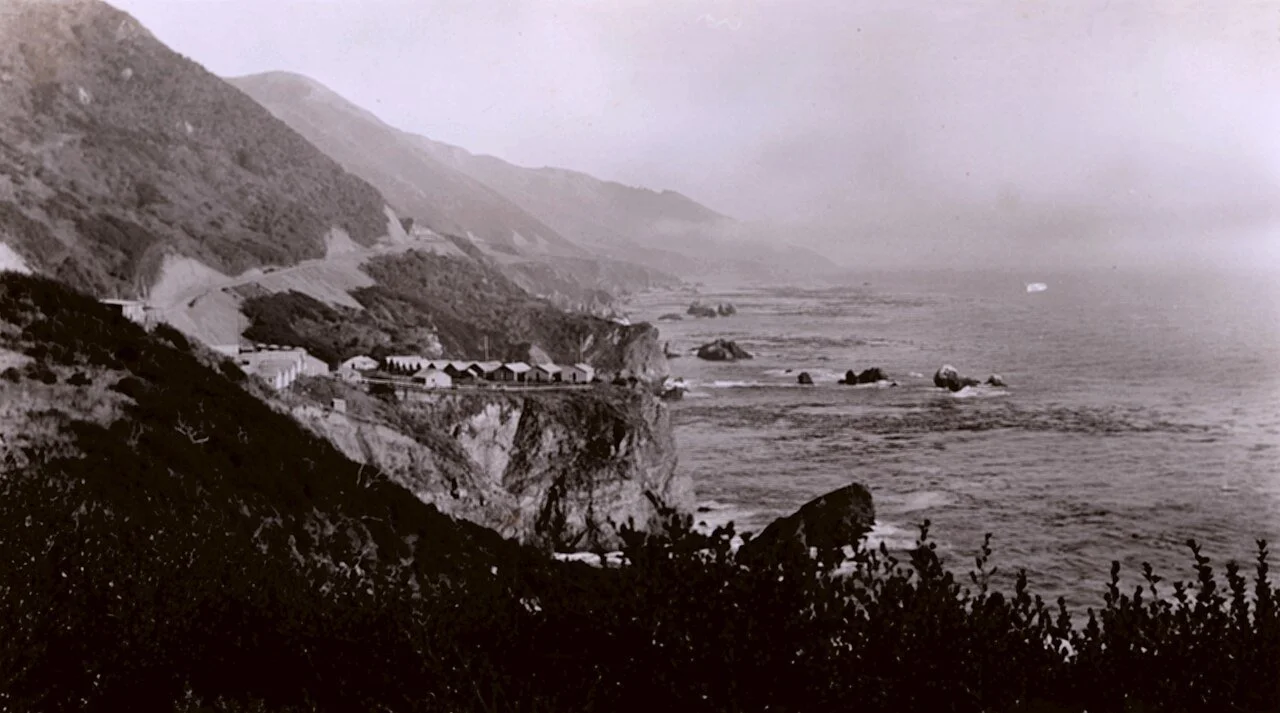
Prison labor camp associated with the construction of Highway 1 through Big Sur, photographed between approximately 1930 and 1936. Floyd Risvold, U.S. Coast & Geodetic Survey / NOAA. Public domain.
The photograph provides a remarkable glimpse of the living and working environment surrounding the construction project. It also reminds us that the road enjoyed by millions of travelers today was created through a combination of engineering innovation, physically exhausting labor, and the use of incarcerated workers.
How Much Dynamite Was Used to Build Highway 1?
One of the most fascinating aspects of Highway 1's construction is the enormous quantity of explosives required to carve a route through the Santa Lucia Mountains. The Federal Highway Administration reports that approximately 70,000 pounds of dynamite were used to blast through granite, marble, and sandstone during the project, while more than 10 million cubic yards of rock were removed.
However, another historical account raises an interesting question about that commonly repeated dynamite figure. Historical materials preserved by the Point Sur Lighthouse describe an enormous blast at Limekiln Point involving approximately 70,000 pounds of dynamite in a single explosion. That blast reportedly moved about 95,000 cubic yards of rock, demonstrating the extraordinary scale of the excavation.
If the Limekiln account is accurate, the frequently cited figure of 70,000 pounds cannot represent the total quantity of dynamite used during the entire highway project. Numerous other sections of the coastline required blasting, and the precise cumulative amount of explosives remains uncertain in the surviving historical records.
Crews drilled holes and tunnels into rock formations, placed explosive charges, and detonated portions of the mountainside to create enough space for the new roadway. Some operations involved relatively small cuts, while others required enormous blasts intended to move thousands of cubic yards of material at once.
It is difficult to imagine the spectacle of one of these major explosions along the Big Sur coastline in the early 1930s. Entire sections of rock could break apart and tumble toward the Pacific, leaving behind a newly exposed surface where engineers could continue cutting the highway into the mountain.
The road was not simply laid across the landscape. Much of it was literally blasted into existence, and the process permanently altered portions of the coastline. Contemporary residents witnessed dramatic changes as rock formations were excavated and debris moved down steep slopes toward the ocean, creating a lasting tension between improved public access and preservation of the natural landscape.
Bixby Creek Bridge: The Highway's Greatest Engineering Landmark
While excavating the mountainsides was an enormous undertaking, crossing Big Sur's deep coastal canyons presented an equally formidable challenge. Numerous bridges were needed along the route, but none would become more famous than Bixby Creek Bridge, located approximately 13 miles south of Carmel.
Engineers initially considered an inland alignment that would have required a tunnel and a smaller bridge farther upstream. Instead, they selected the dramatic coastal crossing that travelers recognize today, a decision that required a much larger structure but preserved the highway's direct route along the ocean.
Construction began in 1931, and the design called for a reinforced-concrete arch spanning the deep canyon. To support the structure while the concrete was being placed and cured, workers erected an enormous temporary wooden framework known as falsework. Approximately 300,000 board feet of timber were needed to construct these supports, demonstrating the scale of the temporary engineering required before the bridge itself could be completed.
Working hundreds of feet above the canyon floor, crews assembled reinforcing steel, positioned forms, poured concrete, and gradually completed the massive arch. The process required careful coordination because the structure needed to remain stable throughout construction, particularly as the temporary supports carried enormous loads before the completed arch could support itself.
Historical photograph: Bixby Creek Bridge under construction, 1932
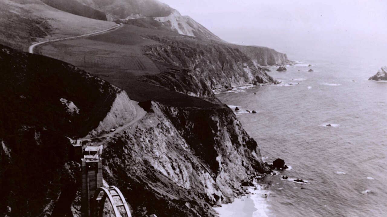
Bixby Creek Bridge under construction in 1932. The enormous temporary timber falsework supported the reinforced-concrete arch during construction. Floyd Risvold, U.S. Coast & Geodetic Survey / NOAA. Public domain.
Completed in 1932, Bixby Creek Bridge measures approximately 714 feet long, with a main arch span of 360 feet, and rises about 260 feet above the canyon below. Its original construction contract was approximately $200,000, a remarkable investment for a single bridge during the early years of the Great Depression.
The bridge was both an engineering accomplishment and an architectural statement. Its graceful concrete arch was designed to complement the surrounding coastline rather than overwhelm it, establishing an approach that would influence the visual character of other structures along Highway 1.
More than nine decades later, Bixby remains one of California's most recognizable landmarks. It is also one of my favorite places to stop along the coast, not simply because of the extraordinary view, but because the bridge represents the ambition and determination required to construct the highway.
For visiting and photography information, see the Bixby Creek Bridge section of my Big Sur Road Trip Itinerary & Travel Guide.
The Other Bridges That Made the Highway Possible
Bixby Creek Bridge was only one part of a much larger bridge-building effort. The Carmel–San Simeon Highway required numerous crossings over streams and canyons descending from the Santa Lucia Mountains toward the Pacific, each presenting different geological and engineering challenges.
Concrete arch bridges were constructed at several locations, including Rocky Creek, Granite Creek, Garrapata Creek, and Malpaso Creek. The designers often favored forms and materials that would harmonize with the rugged coastal landscape, helping establish the distinctive architectural character of the completed highway.
Historical photograph: Six bridges on the Carmel–San Simeon Highway, 1937
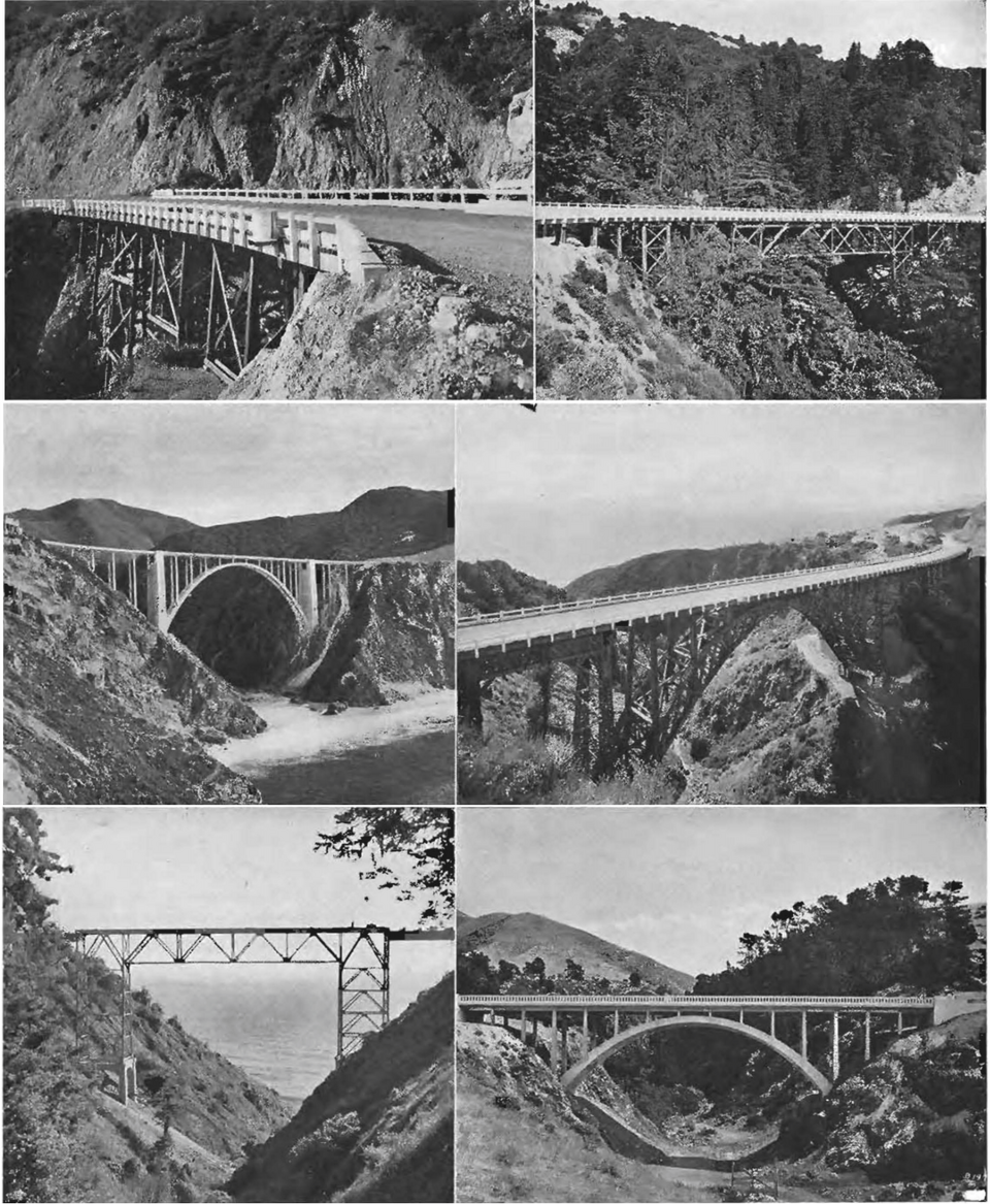
Six bridges along the Carmel–San Simeon Highway, photographed for California Highways and Public Works in July 1937. California Department of Public Works. Public domain.
The bridges were complemented by stone retaining walls, drainage structures, culverts, and other roadside features. Some of these elements were built with natural materials and designs intended to blend with their surroundings, and examples of this historic craftsmanship can still be seen along Highway 1 today.
Although travelers naturally focus on the dramatic cliffs and ocean views, these bridges and roadside structures represent an important part of California's engineering and architectural heritage.
Who Paid for the Big Sur Highway?
The Carmel–San Simeon Highway was primarily a publicly financed construction project, supported through a combination of state funding and later federal assistance. Its first major financial authorization came through California's 1919 highway bond program, which allocated approximately $1.5 million toward construction.
That amount quickly proved insufficient as engineers encountered unstable slopes, difficult terrain, equipment losses, and the high cost of transporting materials into remote coastal areas. California's evolving highway financing system, including revenues from gasoline taxes, provided additional support during the following years, although financial limitations repeatedly slowed construction.
The Great Depression brought another important source of assistance through federal highway programs associated with President Franklin D. Roosevelt's New Deal. Federal funding during the 1930s helped support unfinished sections of the highway, allowing construction to continue toward completion.
The state also reduced direct labor expenses through the use of incarcerated workers, although this arrangement formed part of a much larger system of prison labor whose human consequences should not be overlooked.
Ultimately, the highway was paid for through multiple sources of public financing over many years, reflecting the changing economic and political circumstances surrounding its construction.
How Much Did Highway 1 Cost to Build?
The final cost of the Carmel–San Simeon Highway is generally estimated at approximately $8 million to $10 million in 1930s dollars, although historical sources differ slightly depending on the accounting method and which construction expenses are included.
Caltrans' Big Sur Coast Highway Management Plan gives a figure of approximately $8 million, while the Cambria Historical Society describes the completed road as costing approximately $10 million. Both estimates are dramatically higher than Dr. Roberts' original $50,000 projection made in 1897.
The enormous difference reflects the difficulty of transforming a theoretical coastal route into a functioning automobile highway. The project required extensive excavation, elaborate bridges, specialized equipment, remote construction camps, and continuous repairs to unstable slopes.
It was far more than an ordinary road-building project. Engineers were attempting to create a continuous transportation corridor through mountains that rise almost directly from the Pacific Ocean, a landscape where even maintaining a narrow trail could present significant challenges.
September 18, 1934: The Construction Crews Finally Meet
After years of excavation, blasting, bridge building, and financial setbacks, an important milestone arrived on September 18, 1934, when construction crews working from opposite directions finally connected their sections of the route.
For the first time, a small number of official automobiles could travel the entire distance between San Simeon and Carmel, although the highway remained far from complete. Some sections were still narrow, temporary crossings were required, and additional grading, bridge work, and surfacing needed to be finished before the road could safely accommodate regular public traffic.
Nevertheless, the achievement demonstrated that the seemingly impossible coastal route could become a reality. After more than a decade of difficult construction, the two halves of the highway had finally been connected.
June 27, 1937: Highway 1 Opens Through Big Sur
On June 27, 1937, California officially celebrated the completion of the Carmel–San Simeon Highway, marking the end of one of the most ambitious road construction projects in the state's history.
Governor Frank Merriam led a ceremonial motorcade through the completed route, with celebrations beginning near San Simeon and continuing north toward Pfeiffer Redwoods State Park. Among those attending was Dr. John L. D. Roberts, the physician whose experiences along the coast decades earlier had helped inspire the project.
Senator Elmer S. Rigdon, whose political efforts had been essential in obtaining approval and funding, had died years before the road was completed. His widow participated in ceremonies honoring his contribution to the highway's creation.
At the dedication, a boulder was symbolically removed from the roadway using a bulldozer, marking the opening of the long-awaited coastal route. After years of political debate, financial setbacks, construction accidents, prison labor, dynamite blasting, and bridge building, the Carmel–San Simeon Highway was finally open.
For the first time, ordinary motorists could drive continuously through a coastline that had previously required difficult journeys by horseback, wagon, or boat. Big Sur had entered a new era, and the highway would fundamentally change the region's relationship with the rest of California.
Highway 1 Changed Big Sur Forever
The completion of Highway 1 brought new opportunities to the Big Sur coast, allowing travelers to experience landscapes that had previously been accessible to relatively few people. Tourism expanded as lodges, restaurants, campgrounds, and other visitor services developed along the route, gradually transforming the region into one of California's most celebrated destinations.
However, the highway also introduced concerns about development, traffic, and the preservation of the coastline's natural character. Improved access brought economic opportunities, but it also increased pressure on a landscape that had remained relatively isolated for generations.
These competing interests between public access, private property, commercial development, and conservation continue to shape Big Sur today.
For me, part of what makes this coastline so remarkable is that much of its wild character remains. Despite the road, bridges, and generations of visitors, the Pacific continues to crash against towering cliffs, fog moves slowly through the mountains, and enormous stretches of coastline remain undeveloped.
Highway 1 Is Still Being Built
In a sense, the construction of Highway 1 never truly ended. The same geological forces that challenged the original engineers continue to threaten the roadway, requiring constant maintenance, reconstruction, and occasionally enormous efforts to reopen sections damaged by landslides.
The Santa Lucia Mountains are steep, geologically active, and highly susceptible to erosion. Heavy rainfall can saturate hillsides, while unstable rock formations and fractured slopes sometimes fail without warning, sending enormous quantities of material toward the ocean.
In 1983, a major slide near Julia Pfeiffer Burns State Park caused a prolonged highway closure. Decades later, the massive 2017 Mud Creek landslide buried a section of Highway 1 beneath millions of cubic yards of rock and earth, requiring an extensive reconstruction project. More recently, Regent's Slide caused another lengthy interruption before the route fully reopened in January 2026.
Modern highway crews have equipment, geological monitoring systems, and construction techniques that the original builders could scarcely have imagined, but the fundamental problem remains unchanged. The roadway occupies a narrow corridor through mountains that are constantly being reshaped by weather, gravity, and geological movement.
Keeping Highway 1 open is therefore an ongoing engineering challenge, and every major landslide serves as a reminder of just how difficult the original construction must have been.
Before planning a trip, visitors should always check current conditions using Caltrans QuickMap.
Why This Road Matters to Me
I have painted the Big Sur coastline for years, returning repeatedly to places near Garrapata, Kirk Creek, Point Sur, Partington Cove, and the rocky headlands along the southern coast. Some of my favorite painting sessions begin with a simple stop beside Highway 1, followed by hours watching the light change across the Pacific.
Yet without the highway, many of these places would be nearly impossible to reach with painting equipment. The turnouts, canyon crossings, and stretches of pavement winding above the ocean have made it possible for generations of artists, photographers, writers, and travelers to experience this extraordinary landscape.
Every roadside painting location tells two stories. One belongs to the coastline itself, with its cliffs, changing weather, waves, and remarkable light. The other belongs to the people who made access possible, including the engineers, contractors, laborers, and incarcerated workers who spent years carving a route through the mountains.
There is also a connection to my writing. My historical novel Partington Cove begins in 1928, the same year prison labor camps became part of Highway 1's construction history. The story follows Ingrid Halvorsen and a discovery of jade along the remote Big Sur coastline, exploring a world where isolation still influenced daily life.
My other novel, The Light at Point Sur, was inspired by the real 1935 loss of the U.S. Navy airship Macon off Point Sur, just two years before the highway officially opened.
Both stories are fictional, but their historical settings and coastal landscapes are real. They grew from years of exploring, researching, and painting this extraordinary stretch of California.
You can also explore my original Big Sur oil paintings, inspired by the same cliffs, waves, and coastal light that have drawn me back to Big Sur for so many years.
The Next Time You Drive Big Sur
The next time you cross Bixby Creek Bridge or follow Highway 1 above the Pacific, take a moment to look beyond the scenery and consider the road itself. Notice where solid rock has been cut from the mountainside, how retaining walls support the narrow highway, and how graceful concrete bridges carry traffic across deep canyons that once required long inland detours.
Imagine building those structures with early twentieth-century machinery, steam shovels, wooden scaffolding, hand-operated drills, and explosives, all while working on unstable cliffs high above the ocean. Consider the determination required to continue construction through years of accidents, financial setbacks, and political challenges.
Highway 1 is usually treated as the way we get to Big Sur, but the road itself is one of the region's great historical landmarks. Understanding how it was built adds another layer to the experience of traveling through this remarkable coastline, connecting the natural beauty we see today with the extraordinary human effort that made it accessible.
And for those of us who return to Big Sur again and again, that history makes the journey even more meaningful.
Frequently Asked Questions About Highway 1 in Big Sur
When was Highway 1 through Big Sur built?
Construction began in the early 1920s, and the Carmel–San Simeon Highway officially opened on June 27, 1937. The project required nearly two decades of construction, financial assistance, and complex engineering.
Who originally proposed the Big Sur highway?
Dr. John L. D. Roberts, a Monterey Peninsula physician, was one of the highway's earliest and strongest advocates after traveling to assist survivors of an 1894 shipwreck near Point Sur. California State Senator Elmer S. Rigdon later helped secure the political support and public funding required for construction.
Who paid for Highway 1 through Big Sur?
The highway was financed through California state highway bonds and additional state highway revenues, supplemented by federal assistance, including funding provided during the New Deal era of the 1930s.
Did prisoners help build Highway 1?
Yes. Beginning in 1928, incarcerated men from California's prison system worked in temporary camps along the Big Sur coast. They performed much of the physically demanding manual labor required to complete difficult sections of the highway.
How much dynamite was used to build Highway 1?
The Federal Highway Administration cites approximately 70,000 pounds of dynamite, but other historical materials describe a single blast involving that quantity at Limekiln Point. The precise amount used across the entire project remains uncertain, although explosives played a major role in carving the route through the mountains.
How much did Highway 1 cost to build?
Historical sources generally estimate the final construction cost at approximately $8 million to $10 million in 1930s dollars, considerably more than the early estimates proposed by the highway's original advocates.
When was Bixby Creek Bridge built?
Bixby Creek Bridge was completed in 1932, approximately five years before the entire Carmel–San Simeon Highway officially opened. Its reinforced-concrete arch spans approximately 360 feet across the canyon.
Why does Highway 1 experience so many landslides?
Highway 1 follows steep coastal mountains characterized by unstable rock formations, erosion, and frequent heavy winter rainfall. These conditions can cause slopes to fail, burying or damaging sections of roadway and requiring extensive reconstruction.
Continue Exploring Big Sur
Big Sur Road Trip Itinerary & Travel Guide
Plan your journey along Highway 1 with 24 scenic stops, beautiful beaches, historic landmarks, campgrounds, photography locations, and one-, two-, and three-day itineraries.
Explore My Original Big Sur Paintings
Discover original oil paintings inspired by the California coast, from crashing Pacific waves to rugged cliffs, quiet coves, and the constantly changing light of Big Sur.
Discover My Historical Novels of Big Sur
The Light at Point Sur and Partington Cove explore the history and landscapes of Big Sur through fictional stories rooted in the region's remarkable past.
Historical Sources and Further Reading
California Department of Transportation, Big Sur Coast Highway Management Plan
Federal Highway Administration, California's Pacific Coast Highway
Wikimedia Commons, Historic Bixby Creek Bridge Construction Photograph
Wikimedia Commons, Historic Bridges of the Carmel–San Simeon Highway
Historical sources differ on some construction figures, including the final cost, number of bridges, and total dynamite consumption. Where records are inconsistent, the figures presented here are approximate.
Pavel Gazur
Pavel Gazur is a California coastal oil painter and author of two historical novels set in Big Sur, The Light at Point Sur and Partington Cove. His work is inspired by years of painting, exploring, and experiencing the rugged California coastline.